Sunlight Radiation Analysis in Urban Scenario using Layered Accumulative Shadow Map
Woosuk Shin1 and Nakhoon Baek1,2,3
1 Department of Computer Science and Engineering
2 Software Technology Research Center
3 Dassomey.com Inc.
Kyungpook National University
Daegu, Republic of Korea
oceancru@gmail.com
Abstract
In modern architecture, duration and reachability of direct sunlight is important factor for designing buildings. However, measuring specific amount of sunlight in real environment comes with many constraints and time-consuming task. Therefore, architects use sunlight analysis modules integrated in CAD system like “Rhinoceros 3D” or “Autodesk Revit” that simulates emitting of rays from sun to analyze amount of sunlight. Our previous work proposed another way of analyzing sunlight using accumulative shadow map, which utilize both depth shading and parallel processing features of GPU. In this paper, we also design a method to analyze sunlight duration in urban scenario that consists of high story buildings by vertically layering accumulative shadow map.
Keywords-sunligh radiation analysis; depth shading; parallel processing
1. Introduction
As high story buildings constructed these days, blocking another building’s direct sunlight frequently happens in urban areas. As a result, many lawsuits are held to protect their right to light. Hence, authorities like United Kingdom law commission has published recommendations for buildings to protect right to light [1]. Thus, to prevent shading other buildings and follow local regulations on right to light, architects use sunlight analysis systems integrated in Computer-aided design (CAD) system prior to actual construction of buildings.
Study on analyzing amount of sunlight is actively researched and developed according to [2] and [3]. They have researched about analyzing duration of sunlight by simulating sun’s vector (path) and tracing emitted light of the sun onto geometry. Although we can compute these operations in a relatively short time with aid of massively parallel processing techniques, they have some limitations. Among limitations, the biggest drawback of current sunlight analyze systems is that they can conduct limited analysis on few user defined sample points or grid cell of geometry.
In this paper, we introduce our design to analyze reachability and duration of sunlight not only for user defined sample points, but also on whole geometry using layered accumulative shadow map. Moreover, we also adapt our design to analyze sunlight in urban scenarios, which consist of many high story buildings.
2. Accumulative Shadow Map
In this section, we
will briefly introduce our previous research, accumulative shadow map. In [4],
we discussed accumulative shadow map, which is effective method to analyze
duration of direct sunlight of given geometry and period. We can summarize acquiring process of accumulative shadow map
into several steps. First, build depth map of whole geometry by using depth
shading with single light source, Sun. Then project depth map onto bare ground
of geometry. As a result, we can acquire a single image and we call this shadow
map. Next, acquire other shadow maps consecutively by changing light sources’
position, which is Sun’s path within given period. After that, we can
accumulate all shadow maps by adding each pixels’ value and divide it by the number
of shadow maps. Finally, we can calculate average
duration of direct sunlight of given geometry ![]() by (1).
by (1).
![]() (1)
(1)
2.1. Adaption to Urban Scenario
As we introduced method on generating accumulative shadow map, we can generate “Fig. 2” which is annual accumulative shadow map for of given geometry in our scenario, “Fig. 1”. As we can notice on “Fig. 1”, the area we want to analyze amount of direct sunshine is dark-highlighted area. Several buildings surround this area and each building has different heights.
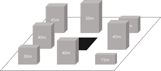
Fig. 1 Geometry of urban scenario used in this paper
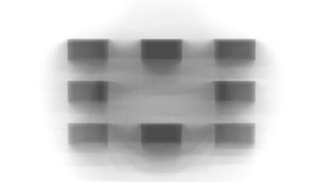
Fig. 2 Annual accumulative shadow map of the geometry
We have already analyzed dark-highlighted area’s duration of direct sunlight, and the result is as shown in Table 1.
Table 1. Analysis result for an geometrical area used in our scenario
|
|
Min. |
Avg. |
Max. |
|
|
0.600 |
0.607 |
0.631 |
|
|
492 |
498 |
517 |
As we can see in the Table 1, at most 60% of direct sunlight is reachable to the area. Since the average daylight hour of given geometry is about 13 hour and 40 minutes, we can calculate average duration of direct sunlight as 517 minutes accordingly. Note that this method assumes that there’s no interference of weather conditions while creating shadow maps. It means, in real-life, reachability and duration of direct sunlight will decrease dramatically.
2.2. Limitation of Accumulative Shadow Map
Though we can acquire precise analysis data of the geometry in relatively short time manner using presented method, accumulative shadow map, it has a limitation to its born. The most critical limitation is, since it was originally designed to analyze effect of surroundings on bare ground by simulating occlusion of direct sunlight, it has limitation in analyze effect of it on high story buildings. That is, since the analyze data is based on a bare ground model, as we analyze data of higher story buildings, error becomes bigger. To overcome this limitation, we design yet another way of analyzing sunlight radiation analysis.
3. Designing Layered Accumulative Shadow Map
To overcome limitation
we mentioned in last section, we introduce layered accumulative shadow map.
“Fig. 3” shows our synopsis of layered accumulative shadow map. Each layer is
accumulative shadow map which is projected on a same geometry with only
different elevation of bare ground. We can simply define each layers’ distance ![]() by dividing
by dividing ![]() by
by ![]() , where
, where ![]() is target elevation
of analysis area (or building) and
is target elevation
of analysis area (or building) and ![]() is user defined
number of layers.
is user defined
number of layers.
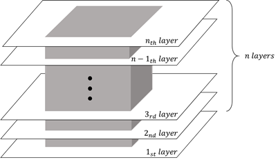
Fig. 3 Synopsis of Layered Accumulative Shadow Map
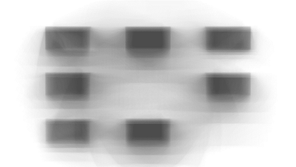
Fig. 4 5th
layer of Layered accumulative shadow map for our scenario, where ![]()
“Fig. 4” shows. And our analyzed data for given geometric, especially for 5th layer of Layered accumulative shadow map. We can see that as layer is higher than bottom-right building, it’s effectiveness to another geometry is not represented. Analyzed data for given layer is shown in Table 2.
Table 2. Analyzed data for 5th layer of accumulative shadow map for our scenario
|
|
Min. |
Avg. |
Max. |
|
|
0.733 |
0.800 |
0.866 |
|
|
601 |
656 |
710 |
As we can check in the table, reachability of direct sunlight to the specific area can get higher as the elevation of interested area is getting high. Hence, we can plan the area to use lower part, where reachability is lower than given time, as non-residential area like parking lots.
We analyzed single layer’s data to acquire exact result, we also can analyze overall geometry’s data. By accumulating each layer, we can get a final accumulated single map for our given geometry. We can analyze effect of the Sun by analyzing this final map in the same was as explained in Section. 2. Note that to acquire this final map, we need to use parallel processing to accumulate multiple layers for real time output, since as number of layer increases, reliability of overall analyzed data gets higher.
4. Conclusion
In this paper, we designed effective way to analyze radiation of sunlight on given period. Our design can analyze whole geometry without sampling small area, whereas recent studies focused on analysis of few sampled points or grids. In addition, our design can be adopted to any scenarios since it is not limited to only urban scenario. Our next goal is to implement system that utilizes our design in near future and compare efficiency and effectiveness of our designed method with other well-known systems like Rhino 3D, Grasshopper 3D, or Autodesk Revit.
Acknowledgment
This study was supported by the BK21 Plus project (SW Human Resource Development Program for Supporting Smart Life) funded by the Ministry of Education, School of Computer Science and Engineering, Kyungpook National University, Korea (21A20131600005).
This study was also supported by Basic Science Research Program through the National Research Foundation of Korea (NRF) funded by the Ministry of Education, Science and technology (Grant 2016R1D1A3B03935488)
References
[1] Great Britain: Law Commission, Law Commission No. 356. Rights to Light, HM Government, 2014
[2] M. H. Pak, A. Smith, and G. N. Gill, “Ladybug : a Parametric Environmental Plugin for Grasshopper to Help Designers Create an Environmentally-conscious Design,” 2013
[3] H. D. Cheung, and T. M. Chung, “Analyzing sunlight duration and optimum shading using a sky map,” Building and Environment, vol. 42, Issue 9, 2007
[4] W. Shin, and N. Baek, "Design and Implementation of a Sunshine Duration Calculation System with Massively Parallel Processing." International Conference on Big Data Applications and Service, Springer, Singapore, 2017.